
 Radio signals don’t travel through empty space.
Out in the real world, they run into hills and valleys, forests and open fields, city blocks, lakes, and objects of every height. That’s why, in network planning, an accurate picture of the environment can matter as much as the propagation model you choose.
Canada shows this well. Dense cities, forests, farmland, lakes, coastlines, and thinly populated regions all sit inside one country.
So what does an RF model need to “see” there?
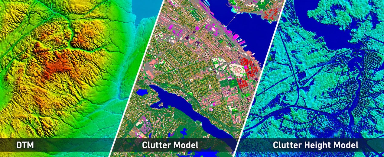
Using one of our 2.5D projects in Canada, let’s go through three layers of geospatial data:
DTM → Clutter → Clutter Height
Each one answers a different question about the same piece of land.
1. DTM: where is the ground?
A Digital Terrain Model (DTM) shows the height of the bare earth, with buildings and vegetation stripped away. It tells the RF model whether a signal path crosses flat ground, a valley, or a mountain ridge.
But a DTM only shows the shape of the ground, not what stands on it. That’s a big gap in Canada, where forests cover about 40% of the country. Two places at the same elevation can have completely different radio conditions.
2. Clutter: what’s on the ground?
A Clutter model sorts the surface into environment types. Depending on the project, that can mean dense and low-rise urban areas, industrial and commercial zones, forests, farmland, open areas, wetlands, and water.
Now the model knows what the signal travels through, not just how high the ground is. And that matters: buildings and trees block the signal and cause diffraction, reflection, and scattering, none of which you can get from terrain data alone.
Still, “forest” or “built-up” doesn’t tell you how tall it is.
3. Clutter Height: how tall is it?
That’s the job of Clutter Height.
Clutter says an area is forest. Clutter Height says how tall that forest is.
The same goes for built-up areas: two zones can share a class and still look very different in height and vertical structure.
That vertical structure shapes how a signal travels, so Clutter Height gives propagation calculations the extra detail they need.
Why is Canada a good RF-planning case?
Canada has large urban areas right next to vast rural and remote territory, so population coverage alone doesn’t tell you much. According to the CRTC (Canadian Radio-television and Telecommunications Commission), mobile service reaches more than 99% of Canadians and 5G about 93%. Coverage is still much lower in rural and remote areas and in Indigenous communities, and in 2023 mobile networks covered around 87% of major roads and highways.
So reaching people and covering territory are two different jobs.
Beyond where the users are, planners need to ask what’s between the transmitter and them.
One area, three views
- DTM shows the terrain.
- Clutter classifies the surface by cover and built-up type.
- Clutter Height shows how high objects rise above the ground.
Together, they give a much fuller picture of the physical environment.
The resolution, classification scheme, and height accuracy you need depend on the network technology, propagation model, frequency band, and the project’s goals. A nationwide plan and a detailed urban 5G model will ask for very different levels of detail, even though both rely on terrain and Clutter data.
A model can only be as accurate as the data underneath it. That’s why we build our 2.5D models as complementary parts of one dataset and adapt resolution, classification, and level of detail to each RF project.
Сontact us at [email protected] — we’d be happy to help.